Trekking Mount Rinjani is an adventure filled with stunning landscapes and breathtaking vistas. Whether you’re an experienced trekker or a novice explorer, having a reliable trekking map is essential for navigating the trails, understanding the terrain, and making the most of your Rinjani journey. In this guide, we’ll provide you with valuable insights into the trekking map for Mount Rinjani.
Understanding the Mount Rinjani Topography
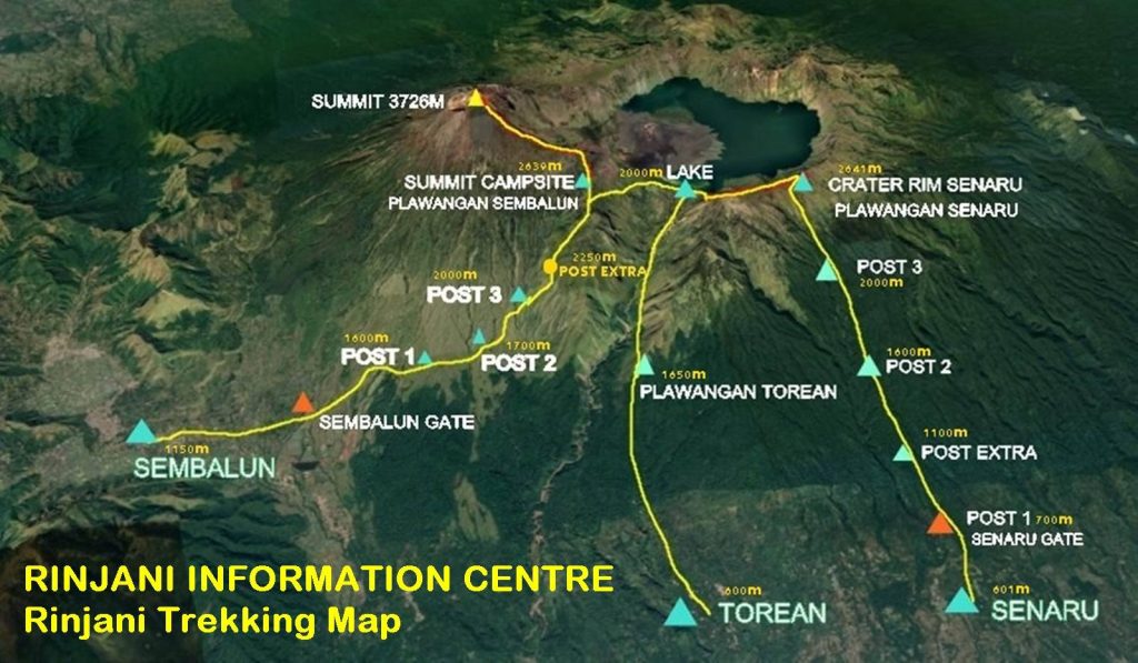
Mount Rinjani, with its towering peak at 3,726 meters (12,224 feet) above sea level, dominates the landscape of Lombok Island in Indonesia. The mountain is part of the Mount Rinjani National Park, and its vast caldera hosts several stunning features, including the SegaraAnakcrater lake and the GunungBaruJari volcanic cone.
Trekking Routes and Key Landmarks
To fully appreciate the trekking map of Mount Rinjani, it’s important to understand the main trekking routes and key landmarks:
Sembalun Route:
- SembalunLawang: This is the starting point for the Sembalun route. It’s a village located on the eastern side of Rinjani, surrounded by lush fields.
- Sembalun Crater Rim: The first major stop offers panoramic views of the crater lake, SegaraAnak.
- Rinjani Summit: The highest point on the trek, providing breathtaking sunrise views.
- SegaraAnak Lake: The stunning crater lake located within the caldera of Rinjani.
- Hot Springs: A natural hot spring near SegaraAnak is a popular spot for relaxation.
- Senaru Rim: The trek descends to the Senaru Rim, providing more captivating views of the crater and summit.
Senaru Route:
- Senaru Village: The starting point for the Senaru route, known for its lush rainforests and waterfalls.
- PlawanganSenaru: A ridge offering panoramic views of Rinjani’s crater and summit.
- SegaraAnak Lake: The pristine crater lake where trekkers can swim.
- Sembalun Crater Rim: The final leg of the trek connects with the Sembalun route.
Timbanuh Route:
- Traditional Sasak Villages: This off-the-beaten-path route offers a chance to interact with local Sasak communities.
- Remote Valleys: Trek through enchanting valleys and forests.
- Senaru Rim: The trek eventually connects to the Senaru route for a complete Rinjani experience.
The Importance of a Trekking Map
A trekking map serves as your guide through the diverse terrain of Mount Rinjani. It helps you understand the trail, anticipate elevation changes, and identify key landmarks. Additionally, a map can be a valuable safety tool, allowing you to stay on course and make informed decisions during your trek.
Where to Obtain a Trekking Map
Trekking Organizers: Trekking with a reputable company like Rinjani Exotic often includes the provision of trekking maps and experienced guides.
Local Visitor Centers: Visitor centers in the area might have maps and informational resources.
Online Resources: There are several websites and apps that offer digital trekking maps and resources for Mount Rinjani.
Before embarking on your Mount Rinjani adventure, ensure you have access to a detailed trekking map. Whether you choose to explore the popular Sembalun and Senaru routes or opt for the less-traveled Timbanuh route, a map will be your trusted companion as you navigate the beauty of this Indonesian gem.